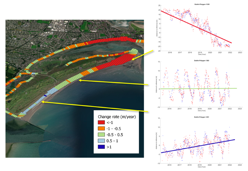
 Change rate product and detailed plots of coastal evolutions showing erosion, stable, and accretion trends.
Monitoring the coastal change from space to mitigate erosion
The goal of the Coastal Change from Space project, funded by the European Space Agency (ESA), was to develop innovative Earth Observation (EO) products/information in response to authoritative requirements from end-users in charge of coastal erosion studies and mitigation.
The Coastal Change from Space project was an application project within the Science for Society block of the 5th Earth Observation Envelope Programme (EOEP-5) of ESA. Its aim was to prepare the basis for long-term exploitation of remote sensing from space by large user communities providing substantial and concrete benefits to the targeted user communities when analysing the trends of coastal erosion and accretion as well as the status of coastal defence works, i.e. vulnerability of the coast.
isardSAT produced waterlines with Sentinel-1 SAR images in order to detect changes around the shoreline and developed a coastal change rate product.
During Phase 1, waterlines for different sites have been generated. During Phase 2, new algorithms were incorporated in the processing chain in order to improve the product reliability. The improvements were applied to three sites (Bull Island and Wexford for Ireland and Start Bay for the UK) and the change rate analysis to assess the erosion and accretion behaviour in these areas was performed.
Go to site